Ghost Rails: A Cold-Weather Walk Along Stow's Lost Railway
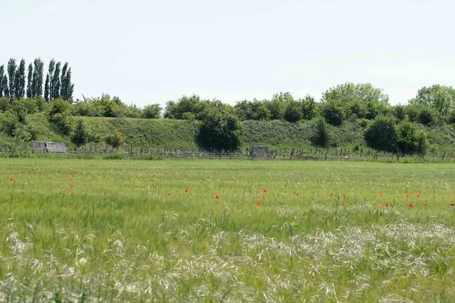
Photo: roger geach, CC BY-SA 2.0, via Wikimedia Commons
There is a stretch of ground on the southern edge of Stow where the earth rises in a long, suspiciously straight hump. It runs behind a hedge, crosses a lane on a low brick bridge, and then simply stops being anything at all. If you didn't know better, you'd take it for an old field boundary. It is, in fact, a railway.
Stow's station is long gone. The trains went first, then the rails, then the buildings, and finally the memory — which is why the line makes such a good walk in November. There's something satisfying about following a route that no longer appears on the timetable, especially when it ends near a decent fire.
The line that put Stow on a timetable
The Banbury and Cheltenham Direct Railway reached Stow in 1881, part of a tangled Victorian ambition to link the Midlands with the West Country without going through Birmingham. It was never a fast line. It curled through the Cotswolds at a speed that suited sheep better than passengers, and Stow's station was a modest affair: two platforms, a goods shed, a siding for cattle, and a nameboard that looked faintly surprised to be there at all.
What the railway did do was change the economics of the town. Coal arrived more cheaply. Milk went out. Livestock came in and out without being walked to market. For a few decades, Stow was connected to the wider world in a way it hadn't been since the coaching era, and the station became a small social hub of its own — porters, parcels, the occasional forgotten umbrella.
The decline was slow and then sudden. Buses and cars nibbled at the passenger trade; wartime economies finished the job. The last regular passenger trains ran in the 1940s, freight lingered into the 1960s, and then the track was lifted. By the time anyone thought to mourn it, the station yard had become a yard, and the embankment had become a place where children played and dogs found interesting smells.
What survives, if you know where to look
You don't need to be a railway obsessive to enjoy this. You just need to know what you're looking at.
- The embankment. The most obvious remnant, running in a clean line through the fields south-west of town. Look for the way the hedge sits on top of it, rather than beside it.
- The bridge. A low accommodation bridge carries a lane over the old cutting. The parapet is original; the road surface is not. Stand on it and you can see the line of the trackbed on both sides.
- Gate piers and fence posts. Scattered along the route, often reused by farmers. One pair of stone piers now guards nothing more exciting than a field gate.
- The old station site. Mostly built over and quietly residential, but the shape of the yard remains, and a couple of walls have the look of railway about them.
- Old maps. The 1880s Ordnance Survey shows the station with its goods shed and siding; the 1920s edition adds a milk dock. Both are worth pulling up on your phone before you set out, or buying from one of the town's shops if you prefer paper. The line is also marked on OS Explorer OL45.
The walk: route notes
Allow about two hours for the full loop, plus stops. It's roughly 3.5 miles, with one steady climb and a couple of stiles. In winter, the trackbed sections hold water — boots rather than trainers, and a walking pole if your knees are as old as the railway.
Start on the square, ideally with a coffee, then head south out of town. Pick up the footpath that runs behind the old station yard and follow the trackbed south-west. The route is not waymarked as a railway — it's just a public footpath — but the alignment is unmistakable once you're on it: straight, level, and bordered by hedges that were planted to keep the line clear.
After about a mile, the trackbed meets a lane. Turn right, then right again, and follow the lane back towards Stow in a wide loop. This is the pretty bit: stone walls, a couple of long views, and the sort of cold, clear light that makes the Cotswolds look as though they've been recently polished. Keep an eye out for the bridge on your left as you come back in.
If you want to extend it, carry on past the bridge and pick up the footpath towards the Fosse Way, then loop back via the edge of town. That adds about a mile and a bit of road walking, which is a fair trade for a different view of the church tower.
The pub finish
Cold-weather walking demands a proper reward, and Stow has no shortage of options. The Porch House, on Digbeth Street, claims to be England's oldest inn and backs it up with low beams, a real fire and a menu that doesn't mess about. The King's Arms on the square is the reliable standby — busy, warm, and well placed for the end of the walk. If you've brought the dog and want a bit more space, The Bell on the edge of town is the sensible choice.
Order something dark and wintery, take your boots off under the table, and consider the fact that a hundred years ago you could have done this journey on a train. It would have been slower, colder, and considerably less comfortable. The embankment, somehow, is the better deal.